GIS Analyst/Programmer

![]() (505) 277-3016
(505) 277-3016
Rick McCanlies developed his affinity for cartography while serving as an Intelligence Analyst and Persian Farsi Linguist in the Army. Following his military service, Rick received a Bachelor of Arts in Linguistics and Middle Eastern Studies from the University of Texas in 2021 and a Master of Arts in Global Environmental Policy with a concentration in GIS from American University in 2024. Rick joined EDAC as a GIS Analyst in 2025.
GIS Analyst/Programmer

Kassandra Merz received her Bachelors in Environmental Sciences (BS) and History (BA) from Susquehanna University in 2017. She has enjoyed an eight year career in utilities mapping and analytics which included mapping the plans for the first construction of 5G infrastructure in the City of Austin, Texas at Verizon Business and creating a comprehensive data map of all state owned right of way for the Texas Department of Transportation. She is now a full-time GIS Programmer Analyst at EDAC.
 Sep 16,2011
 Comments Off on New Mexico Watch – Active Wildfire Mapping Site
 All Projects,Historic Projects
This project is no longer active

The “New Mexico Watch – Active Wildfires” was a public website developed and hosted by the Earth Data Analysis Center that provided information about active wildfires in the state of New Mexico. NMWatch integrated local data (public schools, hospitals, fire stations, law enforcement, community centers, watershed boundaries) with active wildfire perimeter and location information generated daily by the Geospatial Multi-Agency Coordination Group (GeoMAC). Local fire information was added as available from NM Fire Info (New Mexico Fire Information). Users were able to measure distance and calculate area using built-in tools.
Sep 16,2011
Comments Off on Office of the State Engineer Historic Map Georectification
All Projects,Image Processing Projects
In 2010 and 2011 EDAC contracted with the New Mexico Office of the State Engineer to georectify several hundred historic water-related maps. The first project was to georectify hydrographic survey maps of the Pecos Basin using the 2005 statewide digital aerial imagery as the mapping base. Some of the maps date as far back as the 1920s. Following the completion of that project EDAC moved to the western side of the state to do a second map georectification project in the Gila / San Francisco Basin. These maps are called Proof of Beneficial Use (PBU) maps and are used in validating historical water use within the state. These maps were especially difficult to georectify because there was almost no control point information on the maps except for the PLSS section and quarter section corners. Because of that, we were unable to use a photo map base as was done in the Pecos Basin project. The best mapping base that could be found was the statewide PLSS shapefile and the digital raster graphic (DRG) mosaic of the USGS 1:24,000 map sheets.

Sep 16,2011
Comments Off on Petroglyph National Monument Land Cover Mapping Project
All Projects,Image Processing Projects
From 2007 to 2011, EDAC, in conjunction with Natural Heritage New Mexico, mapped the land cover of the 7,000-acre Petroglyph National Monument. Although covering a relatively small area, the park with its volcanoes and lava cliffs found at the transition between the Great Plains, the Desert Basin, and the Chihuahuan Desert communities has a fair amount of diversity. The mapping process combined multi-temporal high and moderate spatial resolution satellite imagery and digital ortho-photos along with field plot data to create the map. The resulting map grouped several dozen vegetation communities identified at the park into some 25 separate land cover types ranging from barren lava rocklands to grasslands and shrublands. The resulting map provides the US Park Service with a data source to aid in their management of park resources and a baseline from which to compare future changes.

Sep 14,2011
Comments Off on Harris County Ortho-Photography Project
All Projects,Image Processing Projects
As part of a project being conducted by URS Corp to map the land-use change in Harris County, Texas (greater Houston), EDAC was contracted in 2011 to create an ortho-photo map of the county using aerial photography acquired in 1983. At that time the National High Altitude Program acquired some 117 color IR photos over the area. Photo transparencies were obtained from the USGS and scanned at 2,000 dpi. The scanned photos were then rectified to the most recent photo base map for the county while using USGS 10 m spatial resolution DEMs for the elevation values. The resulting ortho-photos were mosaicked together to create the 1983 ortho-photo map at 1m spatial resolution.

Aug 5,2011
Comments Off on GIS as a Powerful Communication and Community Empowerment Tool (Sample Poster)
Sample Products

Jul 22,2011
Comments Off on New Mexico Public School Facilities Authority – Webmap
All Projects,Historic Projects
This project is no longer active
 The New Mexico Public Schools Facilities Authority (PSFA) Statewide Web map was developed to communicate information about public schools in the State of New Mexico. The Web Map displayed public school information including school enrollment numbers, school capacity calculations, the New Mexico Facilities Database ranking information, and community assets are presented in tabular and graphical formats.
At the beginning of almost every legislative session, EDAC provides representatives of New Mexico’s Senate and House Districts with maps depicting the locations of University of New Mexico (UNM) Students, Employees, and Alumni within the individual districts. According to Marc H. Saavedra, UNM’s Director of the Office of Government and Community Relations, “The legislators really appreciate having the map at the start of every legislative session. The map also plays a big role in making the legislature aware of how UNM is across the entire State and in their district.”

Jul 5,2011
Comments Off on Probability and Risk Assesment of Sewer Line Failure (Sample Model)
Sample Products

Jun 6,2011
Comments Off on UNM Natural Hazards Pre-Disaster Mitigation Plan
GIS Projects,All Projects
The Pre-Disaster Hazard Mitigation Act of 2010 (PDM), administered by the Federal Emergency Management Agency (FEMA), provides funding and technical assistance to state and local governments for disaster preparedness and management. Over the last two years, UNM has developed the first university-approved Natural Hazard Pre-Disaster Mitigation Plan in New Mexico. The ongoing program aims to develop ways to reduce the impact of natural disasters on UNM’s resources by identifying natural hazards and associated risks applicable to UNM, determining the impacts of these hazards, setting mitigation goals, and developing strategies that would lessen potential impacts.
EDAC’s role in the plan is to perform a fundamental analysis of top hazards likely to affect UNM by identifying such as thunderstorms, lightning, hail, winter storms, extreme cold/heat, wind/dust storms, tornadoes, flooding, wildfires, drought, and earthquakes and by incorporating factors such as building age, building use, and building function to properly assess the risk associated with various hazards. Through output maps and reports, hazard awareness can be better understood and shared. Priorities then can be established and the mitigation plan implemented.

Because universities provide structure and stability to local economies and directly influence their surrounding communities, states, and local governments, having a Pre-Disaster Mitigation Plan that saves lives, reduces damage and monetary loss, and keeps universities’ doors open and fully operational is essential.
Sep 14,2010
Comments Off on International Charter on Space and Major Disasters
All Projects,Image Processing Projects
Started in 1999, the International Charter on Space and Major Disasters is a cooperative agreement between the world’s major space agencies to pool their remote sensing satellites and archival imagery libraries to aid countries whose people are impacted by natural or man-made disasters. When a disaster occurs the Charter members decide on what types of satellite imagery are appropriate, initiate new collections by the satellites, and open up their archives for historical imagery. The imagery is then obtained and delivered to first response officials on the ground at no charge to the end users. Should a Charter-eligible disaster strike New Mexico in the future, Paul Neville, GIS Specialist/Programmer, has been selected by the Charter members to be the state Project Manager. He would be in charge of receiving all imagery from the Charter members and delivering it to the local end users in whatever format is chosen.

Dec 3,2009
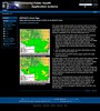
Comments Off on Public Health Nested, Multi-Resolution Dust Forecast System Feasibility Study
All Projects,Image Processing Projects,Information Technology Projects
Exposure to fine particulate dust and adhered endotoxins is an increasing Public Health concern, particularly in the exacerbation of cardiovascular and respiratory diseases. This concern is demonstrated by the deployment (funded by NASA’s REASoN program) of a moderate-resolution dust forecasting system (the DREAM ETA model) into the SYRIS syndromic surveillance system, and through ongoing interest by the NM Department of Health in the deployment of dust, pollen, and other environmental data sets into New Mexico’s Environmental Public Health Tracking Network (EPHTN). In support of these systems, more rapidly available and higher spatial resolution data are needed for more localized assessment of particulate exposure for use in epidemiological studies, and for more timely and targeted notification of dust events to at-risk populations.
Researchers at the University of New Mexico, George Mason University, and the University of Arizona had previously been funded by NASA to conduct an Interoperability Testbed project in 2007 to demonstrate key model and data interoperability capabilities of the Dust Regional Atmospheric Model (DREAM ETA); the higher particle- size resolution, 8-bin DREAM ETA model; and the higher spatial resolution DREAM NMM model.
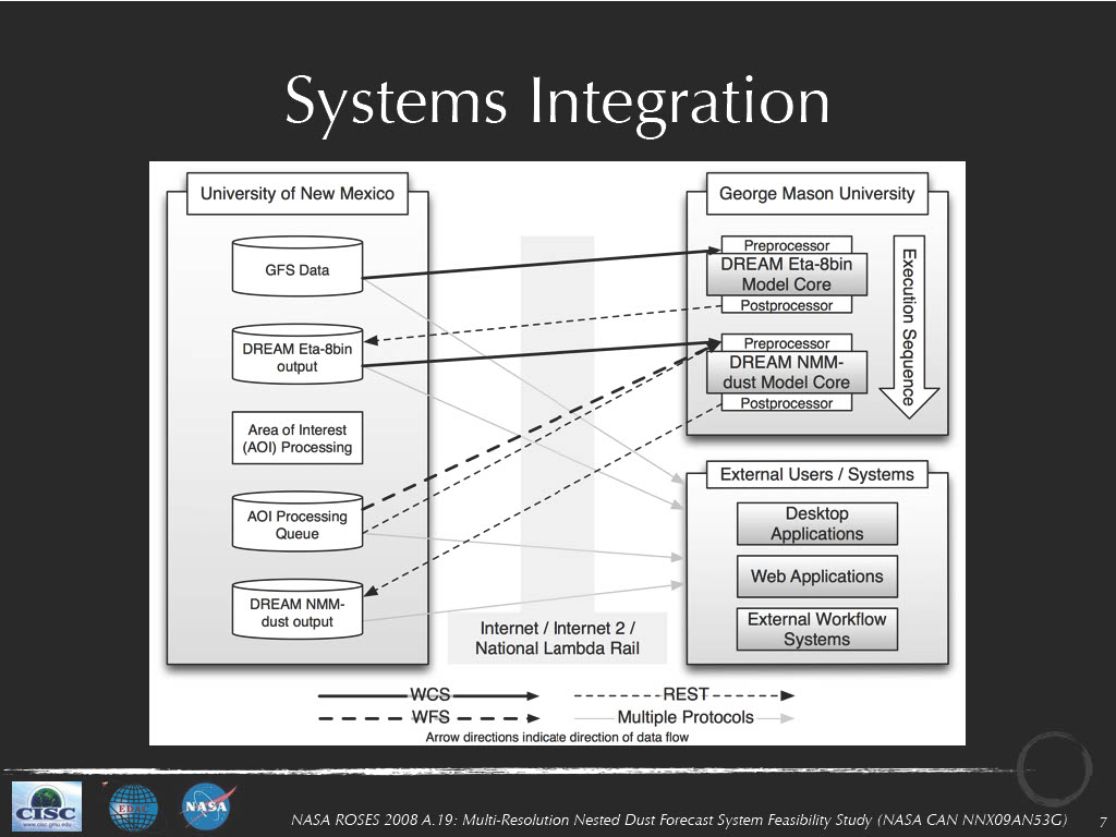
This project builds upon our previous work in the Interoperability Testbed and the PHAiRS projects through two related activities to be undertaken by EDAC and our collaborators at George Mason University (funded by NASA through their 2008 Research Opportunities in Space and Earth Sciences NRA): 1) determining the feasibility of deploying a nested dust forecasting system that consists of initial low spatial resolution (8-bin DREAM ETA) model runs that identify regions for which an HPC-enabled, high-spatial-resolution DREAM NMM model should be run; and 2) developing an interoperable framework that uses OGC and W3C standards to enable model and data interoperability to streamline the execution of the model chain and deliver the products of the model runs into public health decision support systems such as EPHTN and SYRIS.
Sep 15,2009
Comments Off on Bandelier National Monument Land Cover Mapping Project
All Projects,Image Processing Projects
From 2001 to 2009, EDAC, in conjunction with Natural Heritage New Mexico, mapped the land cover of the 34,000-acre Bandelier National Monument in north-central New Mexico. The monument presented some unique challenges, from an elevation difference of 5,000 feet to a terrain that includes riverine and lacustrine habitats, deep incised canyons, and tall peaks capped by sub-alpine forests. In addition, throughout the project, the region underwent a significant ecological change as the ubiquitous pinyon woodlands suffered a near-total dieback. The mapping process combined multi-temporal, moderate spatial resolution satellite imagery with digital ortho-photos along with the field plot data to detect and classify the different mixes of plant cover types. The resulting map grouped the hundreds of separately identified vegetation communities found at the park into 70 separate land cover types. The resulting map provides the US Park Service with a data source to aid in their management of park resources and a baseline from which to compare future changes.

Sep 14,2009
Comments Off on Guadalupe Mountains National Park Land Cover Mapping Project
All Projects,Image Processing Projects
Beginning in 2005, EDAC in conjunction with Natural Heritage New Mexico mapped the land cover of the 86,000 acre Guadalupe Mountains National Park in western Texas. A diverse range of environments are found in the park from the gypsic dunes and alkali playas on the west side, to the oak scrubland on the east side, to the montane conifer forests in the peaks that rise 4,000 feet above the basin floor. The mapping process combined multi-temporal, moderate spatial resolution satellite imagery with digital ortho-photos along with field plot data to detect and classify the different mixes of plant cover types. The resulting map grouped the hundreds of separately identified vegetation communities found at the park into almost 70 separate land cover types. The resulting map provides the US Park Service with a data source to aid in their management of park resources and a baseline from which to compare future changes.

This project is no longer active
This three-year NASA-funded project was built upon EDAC’s combined experience and capabilities built as part of the PHAiRS and NM EPHT projects through the development of dust and ozone forecast products and information delivery capabilities that are deliverable through the NM EPHT system. This project delivered PM2.5 and PM10 raster and aggregated vector data products into the NM EPHT system, and through our past work with modelers at the University of Arizona and NASA’s Marshall Space Flight Center delivered enhanced dust and ozone forecasts into NM EPHT.
Oct 16,2008
Comments Off on Geospatial Technical Assistance to Sandia National Laboratories
All Projects,Image Processing Projects
Almost continuously since 1994, EDAC has provided the Cooperative Monitoring Center (CMC) at Sandia National Laboratories with technical assistance in remote sensing and GIS technology. The mission of the CMC is to demonstrate the various unclassified technologies that can be used in border monitoring, arms control, and international security. EDAC provides expertise in remote sensing and GIS by obtaining satellite imagery and other geospatial data for a variety of CMC international projects. We assist the CMC with border monitoring analyses, modeling, and imagery interpretation. The CMC has a visiting scholars program that hosts a wide range of domestic and international experts, and EDAC assists them with geospatial information and training. We also provide remote sensing presentations and demonstrations at CMC workshops and conferences. Presentations are conducted in Albuquerque, elsewhere domestically, and on occasion, internationally.

 EDAC, in collaboration with UNM’s Bureau of Business and Economic Research (BBER) and under contract to the NM Department of Finance and Administration, addressed the population undercount in the Local Update of Census Addresses (LUCA) Program used to update and improve the U. S. Bureau of Census Master Address File. EDAC used digital aerial imagery for interpreting and counting housing structures within 3,500 Census blocks. These blocks were selected to provide the greatest impact upon areas that are historically the most undercounted due, in large part, to the poor addressing found in these regions. Overall, the program provided an additional 131,283 housing units not previously identified by the Census Bureau enumeration. New Mexico may benefit by as much as $11 million per year in increased federal funding once these additions are accepted by the Census Bureau.
 EDAC, in cooperation with the New Mexico Department of Homeland Security and Emergency Management (DHSEM), continues the partnership among state and Federal agencies, local communities, tribal entities, and professional associations to assess, inventory, acquire, and distribute data that support coordinating, planning, and developing floodplain mapping, as stated in New Mexico’s Map Modernization Management Support (MMMS) business plan. EDAC provides the State with an ongoing coordinated floodplain mapping program. In light of the Flood Map Modernization Mid-Course Adjustment, greater focus has been placed on compliance with FEMA’s 2005 Floodplain Boundary Standard, which includes providing access to the most current and accurate digital data layers. The digital data will be accessible to engineers, local communities, and citizens of New Mexico thus providing officials information required for accurate assessment of risk-based mapping priorities.
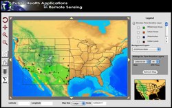 In 2008, the five-year NASA-funded REASoN project known as PHAiRS entered its fifth and final year. This project is unique in that it has successfully modified a dust forecast model for conditions in the southwest United States and improved the model’s performance by using NASA Earth observation data as input parameters. Furthermore, it has engaged the public health communities in Arizona, New Mexico, and Texas in all phases of the project. Significant progress has been made in developing a demonstration web client, the standards-based service-based architecture on which it depends, and the incorporation of EPA in-situ particulate matter concentration data. Most significant is the availability of forecast dust data via Open Geospatial Consortium web services, allowing users to quickly acquire data using time-enabled WMS requests, both through direct requests and through an online KML generation tool for streamlined visualization in desktop virtual globe applications such as Google Earth. In the final months of the project, the PHAiRS capabilities and products will be incorporated into the Syndrome Reporting and Information System (SYRIS) and tested by the City of Lubbock Department of Health and the Texas Department of Health District 1.
Demonstration Movies:
This project is no longer active
 EDAC worked with the National Diabetes Prevention Center (NDPC), Program Development Branch, National Diabetes Wellness Program, and Center for Disease Control and Prevention (CDC) to assist in serving Native communities. As part of the project we developed a public health tool for displaying, analyzing and mapping diabetes in Indian country. This lead to the development of culturally sensitive educational materials, diabetes mapping tools and other GIS/healthcare related products.
This project is no longer active
 EDAC in cooperation with the National Indian Council on Aging, and sponsored by the Indian Health Services (IHS) through the Indian Elder Care initiative developed an interactive Atlas of Indian Elder Health. The interactive atlas provided query capability to IHS databases and displayed the results as maps at national, regional, or local levels. Health data were overlaid with environmental, socioeconomic, and geopolitical data from the US Bureau of Census, the Environmental Protection Agency and other public domain data sources. While targeting Indian elders, the interactive mapping application contained IHS de-identified data for patients of all ages, making it a valuable national healthcare resource for Indian country. The Atlas highlighted the needs and conditions of this special population while providing tools and methods to better understand elders and elder needs.
 In conjunction with our application development work, we also provide ongoing hosting of the applications that we develop for particular projects. The specific hosting model will vary from project to project, but the following services are available as part of any hosting package:
Specific hosting solutions are typically customized to meet the requirements of particular applications. The general capabilities that have previously been deployed and hosted on EDAC’s servers include:
While these solutions are just examples of the numerous application development and hosting solutions that EDAC has developed over the past several years, they illustrate the breadth of options available for hosting services provided by EDAC.
A Digital Elevation Map of New Mexico Derived from the USGS National Elevation Data Set (GIS Sample Product)