In collaboration with the Federal Emergency Management Agency (FEMA) under the Cooperating Technical Partners Program (read more…), EDAC created and manages the New Mexico Wildfire Risk Assessment Portal (NMWRAP). In an effort to increase wildfire awareness, NMWRAP is an interactive web map that allows users to view if they are at risk for wildfires in New Mexico. The web map also has tools for users to create maps, and download data and reports.


The Earth Data Analysis Center provided data collection, data processing, and mapping support to the New Mexico Office of Secretary of State for carrying out work related to the Local Election Act (LEA), which was passed by the New Mexico Legislature in 2018. LEA provides for local elections to be held simultaneously throughout the state of New Mexico. Special voting district boundary data was collected from district contacts and/or their data stewards. The data was processed and made into digital format when necessary, or they can be viewed on the New Mexico Political Subdivisions Map. Voter addresses were standardized and geocoded. Overlay analyses were executed with voter address points, special voting district boundaries, and voting precinct boundaries to determine voter count per area. This work assists in the preparation for future local elections.
The New Mexico 911 (NM911) Program was created by Section 63-9D-1 through 63-9D-20 NMSA 1978 (“Enhanced 911 Act”) to further the public interest and protect the safety, health, and welfare of the people of New Mexico by enabling the development, installation, and operation of enhanced 911 emergency reporting systems to be operated under shared state and local government management and control. The New Mexico Department of Finance and Administration (NM DFA) manages the NM911 Program.
The NM911 Program administers essential emergency reporting and dispatch services accessible by calling nine-one-one through forty-one disparately funded municipal and county-run public safety answering points (PSAPs or 911 centers) located throughout the state.
In January 2019, The NM911 Program contracted with the Earth Data Analysis Center (EDAC) at the University of New Mexico (UNM) and Bohannan Huston, Inc. to securely acquire geospatial data from local government entities, validate and process data into the statewide model; and make such data available for download on the PSAP Map Servers. Earth Data Analysis Center is responsible for securely acquiring GIS data from primary GeoData Providers, verifying and validating data, processing to convert those to the statewide master dataset, generating assessment reports identifying errors or discrepancies per NM911 standards, and providing reports back to the GeoData providers. In addition, these data are updated on PSAP Map servers for emergency response. The road centerlines and address points (statewide) are available on NM RGIS Geospatial Data Clearinghouse as shapefiles for public access.

FEMA’s Risk Mapping, Assessment, and Planning (RiskMAP) Program’s vision is to provide quality data that increases public awareness and leads to action that reduces risk to life and property. The New Mexico Department of Homeland Security (NMDHSEM) and Earth Data Analysis Center are working with FEMA Region VI as Cooperating Technical Partners through RiskMAP to prioritize flood-related data needs throughout the state. NMDSHEM and EDAC operate the NMFlood website that hosts interactive maps, current flood-related news, and links to online flooding tools and are active in the New Mexico Floodplain Managers Association and New Mexico Silver Jackets.
The New Mexico Broadband Program (NMBB) began in 2010 as part of the National Telecommunications and Information Administration (NTIA) State Broadband Initiative (SBI), which implemented the joint purposes of the American Recovery and Reinvestment Act of 2009 and the Broadband Data Improvement Act. The SBI program facilitated the integration of broadband and information technology into state and local economies.
After that initiative was completed, EDAC continued working with the New Mexico Department of Information Technology (DoIT) on several other broadband projects, such as the Governor’s Broadband for Education Initiative, PSFA Broadband Deficiencies Correction Program (BDCP), and the NM Rural Broadband Project (RBBP). In 2022 the Office of Broadband Access and Expansion (OBAE) and the Connect New Mexico Fund (CNMF) were created. This later gave way to the Connect New Mexico Pilot Program (CNMPP), a grant program that allows awarded Internet Service Providers (ISPs) to bring broadband to unserved and underserved communities.
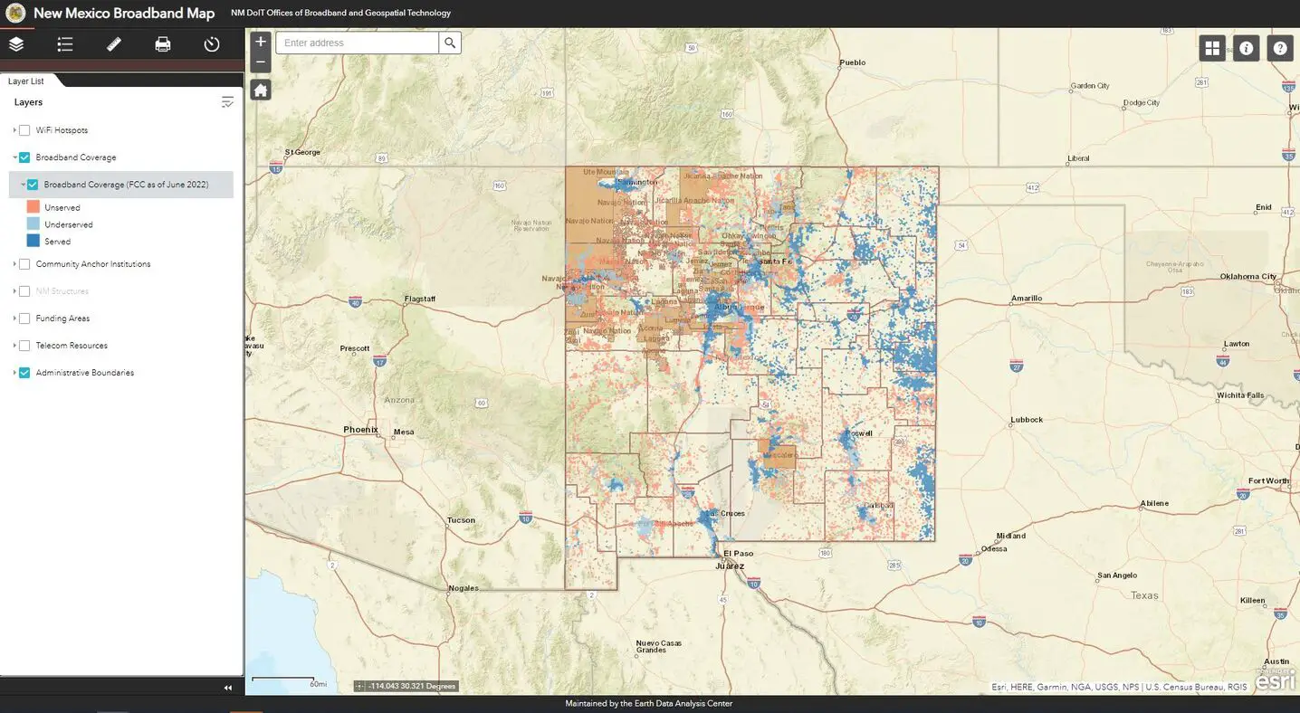
EDAC continues to maintain the New Mexico Broadband Map (NMBB Map), which had originally been created in partnership with DoIT for the NTIA SBI project. The NMBB Map, http://nmbbmapping.org/mapping/, is an interactive web map that displays broadband availability based on download/upload speeds: Served (100/20 Mbps or more), Underserved (from 25/3 Mbps to just under 100/20 Mbps), and Unserved (less than 25/3 Mbps). This data is derived from the Federal Communications Commission (FCC)’s Broadband Serviceable Locations (BSL) data. The NMBB Map also includes other relevant data: Community Anchor Institutions (CASA database), NM structures, funding areas, telecom resources, WiFi hotspots, and administrative boundaries for reference.
The map allows consumers to see broadband availability and policymakers to address the barriers for broadband expansion and to improve broadband adoption in underserved and unserved communities. The adoption of high-speed Internet services and information technology enhances economic development, public safety, health care, educational opportunities, and the quality of life for New Mexicans.
 EDAC attended the NM Department of Health kick-off for New Mexico’s Environmental Public Health Tracking (EPHT) Program in 2002 and has participated in the NM EPHT Program in the years since. New Mexico is an original Grantee in the Centers for Disease Control and Prevention (CDC) National Environmental Public Health Tracking Program and is currently one of 24 EPHT Grantees. This CDC program provides state health departments with resources to create statewide networks that integrate data sets, tools, and standards, thus allowing the state network to be an interoperable component of the National EPHT Network. New Mexico supports the national EPHT goals to prevent or reduce illnesses, injuries, and deaths related to environmental risk factors and to increase the understanding of the relationships between environmental exposures and health effects.
EDAC develops, implements, and enhances the NM EPHT Network/System (NM Tracking) nmtracking.doh.nm.gov and its relevant data services. NM Tracking consists of a content management system for text- and graphics-based information and an interactive, dynamic data analysis, visualization, and reporting application. The portal provides a secured, publicly accessible, Web-based mechanism to exchange data and information between data stewards, analysts, and New Mexicans and the public; to discover and view data; and to explore relationships between environmental exposures and potential health outcomes. To achieve this, NM Tracking uses an online data registry to make environmental public health information, data, and standardized metadata available for query, visualization, download, and report generation. Data security is ensured through secure Internet transmissions, encrypted messaging, and authenticated and authorized user roles in all communications between NM Tracking and the NMDOH environmental health-data provider NM-IBIS and other distributed data providers.
At the beginning of almost every legislative session, EDAC provides representatives of New Mexico’s Senate and House Districts with maps depicting the locations of University of New Mexico (UNM) Students, Employees, and Alumni within the individual districts. According to Marc H. Saavedra, UNM’s Director of the Office of Government and Community Relations, “The legislators really appreciate having the map at the start of every legislative session. The map also plays a big role in making the legislature aware of how UNM is across the entire State and in their district.”

The Pre-Disaster Hazard Mitigation Act of 2010 (PDM), administered by the Federal Emergency Management Agency (FEMA), provides funding and technical assistance to state and local governments for disaster preparedness and management. Over the last two years, UNM has developed the first university-approved Natural Hazard Pre-Disaster Mitigation Plan in New Mexico. The ongoing program aims to develop ways to reduce the impact of natural disasters on UNM’s resources by identifying natural hazards and associated risks applicable to UNM, determining the impacts of these hazards, setting mitigation goals, and developing strategies that would lessen potential impacts.
EDAC’s role in the plan is to perform a fundamental analysis of top hazards likely to affect UNM by identifying such as thunderstorms, lightning, hail, winter storms, extreme cold/heat, wind/dust storms, tornadoes, flooding, wildfires, drought, and earthquakes and by incorporating factors such as building age, building use, and building function to properly assess the risk associated with various hazards. Through output maps and reports, hazard awareness can be better understood and shared. Priorities then can be established and the mitigation plan implemented.

Because universities provide structure and stability to local economies and directly influence their surrounding communities, states, and local governments, having a Pre-Disaster Mitigation Plan that saves lives, reduces damage and monetary loss, and keeps universities’ doors open and fully operational is essential.
 EDAC, in collaboration with UNM’s Bureau of Business and Economic Research (BBER) and under contract to the NM Department of Finance and Administration, addressed the population undercount in the Local Update of Census Addresses (LUCA) Program used to update and improve the U. S. Bureau of Census Master Address File. EDAC used digital aerial imagery for interpreting and counting housing structures within 3,500 Census blocks. These blocks were selected to provide the greatest impact upon areas that are historically the most undercounted due, in large part, to the poor addressing found in these regions. Overall, the program provided an additional 131,283 housing units not previously identified by the Census Bureau enumeration. New Mexico may benefit by as much as $11 million per year in increased federal funding once these additions are accepted by the Census Bureau.
 EDAC, in cooperation with the New Mexico Department of Homeland Security and Emergency Management (DHSEM), continues the partnership among state and Federal agencies, local communities, tribal entities, and professional associations to assess, inventory, acquire, and distribute data that support coordinating, planning, and developing floodplain mapping, as stated in New Mexico’s Map Modernization Management Support (MMMS) business plan. EDAC provides the State with an ongoing coordinated floodplain mapping program. In light of the Flood Map Modernization Mid-Course Adjustment, greater focus has been placed on compliance with FEMA’s 2005 Floodplain Boundary Standard, which includes providing access to the most current and accurate digital data layers. The digital data will be accessible to engineers, local communities, and citizens of New Mexico thus providing officials information required for accurate assessment of risk-based mapping priorities.

