In order to aid in the protection of the dune sagebrush lizard (Sceloporus arenicolus) habitat, Natural Heritage New Mexico (NHNM) is collaborating with EDAC to map its range in detail. The lizard is found only on the shinoak (Quercus havardii) dunelands of southeastern New Mexico, comprising some 1,415,000 acres. As this habitat is a checkerboard of control of federal, state, and private land managers and faces an increasing number of threats from competing land uses, the need to know where important and viable habitat still exists is critical. So beginning in 2011, field crews from NHNM have gone out to the shinoak dunelands and collected and described land cover for a number of ground control plots. These plots have been used by EDAC in turn with multi-temporal Landsat imagery from 2011 as well as the NAIP 2011 digital ortho-photography to create a land cover map at a 1m spatial resolution which is intended to be useful to land managers at a 1:12,000 scale. The area was mapped into 18 different land cover classes, of which the most important is to separate the healthy shinoak dunelands and dune blowouts, which are critical to the survival of the lizard, from areas of disturbance and degraded habitat.

As part of an ongoing national program to inventory and map vegetation cover for all of the 280 park units in the United States, EDAC and Natural Heritage New Mexico (NHNM) developed a vegetation map for the 115,000-acre El Malpais National Monument located in western New Mexico. The rugged nature of the topography dominated by lava flows and volcanoes, some only a few thousand years old, made it especially challenging to gather field data and created much more reliance on the imagery to classify the area. Still, NHNM managed to collect some 476 ground plots from 2003 to 2009 which described the vegetation cover for a sample terrain of 400 m2. These ground data sets were then used by EDAC to create a classification from multi-temporal Landsat imagery and natural color digital ortho-photography. The spectral depth and seasonality of the Landsat imagery was used to model differences in surface reflectance and phenology between vegetation types whereas the photography was used to enhance the spatial resolution of the final product. The resulting map classified the park into 12 Map Unit Level 1 classes (equivalent to the NVCS Group level) and 49 Map Unit Level 2 classes (equivalent to the NVCS Alliance level). The completed maps and accompanying reports have been provided to the US National Park Service as digital products to aid in the present and future management of their natural resources.

As a component of a larger NASA-funded project on the Integration of Airborne Dust Prediction Systems and Vegetation Phenology to Track Pollen for Asthma Alerts in Public Health Decision Support Systems, EDAC is developing a web-based decision support system for forecasting Juniperus ashei, Juniperus monosperma, Juniperus scopulorum, and Juniperus pinchotii pollen concentration data. Designed to meet the requirements of New Mexico’s Environmental Public Health Tracking System (NM EPHTS), the system includes state-of-the-art statistical analysis tools, geospatial visualization tools, data discovery, extraction, and delivery tools, and environmental/public health linkage information. Earth science data obtained from Earth observatories are ingested into the Pollen Regional Atmospheric Model (PREAM) by team members at the University of Arizona. EDAC receives output files from the model which then are run through a post-processing routine to develop products that are made available to NM EPHTS via web mapping and web coverage services.

In 2010 and 2011 EDAC contracted with the New Mexico Office of the State Engineer to georectify several hundred historic water-related maps. The first project was to georectify hydrographic survey maps of the Pecos Basin using the 2005 statewide digital aerial imagery as the mapping base. Some of the maps date as far back as the 1920s. Following the completion of that project EDAC moved to the western side of the state to do a second map georectification project in the Gila / San Francisco Basin. These maps are called Proof of Beneficial Use (PBU) maps and are used in validating historical water use within the state. These maps were especially difficult to georectify because there was almost no control point information on the maps except for the PLSS section and quarter section corners. Because of that, we were unable to use a photo map base as was done in the Pecos Basin project. The best mapping base that could be found was the statewide PLSS shapefile and the digital raster graphic (DRG) mosaic of the USGS 1:24,000 map sheets.

From 2007 to 2011, EDAC, in conjunction with Natural Heritage New Mexico, mapped the land cover of the 7,000-acre Petroglyph National Monument. Although covering a relatively small area, the park with its volcanoes and lava cliffs found at the transition between the Great Plains, the Desert Basin, and the Chihuahuan Desert communities has a fair amount of diversity. The mapping process combined multi-temporal high and moderate spatial resolution satellite imagery and digital ortho-photos along with field plot data to create the map. The resulting map grouped several dozen vegetation communities identified at the park into some 25 separate land cover types ranging from barren lava rocklands to grasslands and shrublands. The resulting map provides the US Park Service with a data source to aid in their management of park resources and a baseline from which to compare future changes.

As part of a project being conducted by URS Corp to map the land-use change in Harris County, Texas (greater Houston), EDAC was contracted in 2011 to create an ortho-photo map of the county using aerial photography acquired in 1983. At that time the National High Altitude Program acquired some 117 color IR photos over the area. Photo transparencies were obtained from the USGS and scanned at 2,000 dpi. The scanned photos were then rectified to the most recent photo base map for the county while using USGS 10 m spatial resolution DEMs for the elevation values. The resulting ortho-photos were mosaicked together to create the 1983 ortho-photo map at 1m spatial resolution.

Started in 1999, the International Charter on Space and Major Disasters is a cooperative agreement between the world’s major space agencies to pool their remote sensing satellites and archival imagery libraries to aid countries whose people are impacted by natural or man-made disasters. When a disaster occurs the Charter members decide on what types of satellite imagery are appropriate, initiate new collections by the satellites, and open up their archives for historical imagery. The imagery is then obtained and delivered to first response officials on the ground at no charge to the end users. Should a Charter-eligible disaster strike New Mexico in the future, Paul Neville, GIS Specialist/Programmer, has been selected by the Charter members to be the state Project Manager. He would be in charge of receiving all imagery from the Charter members and delivering it to the local end users in whatever format is chosen.

Exposure to fine particulate dust and adhered endotoxins is an increasing Public Health concern, particularly in the exacerbation of cardiovascular and respiratory diseases. This concern is demonstrated by the deployment (funded by NASA’s REASoN program) of a moderate-resolution dust forecasting system (the DREAM ETA model) into the SYRIS syndromic surveillance system, and through ongoing interest by the NM Department of Health in the deployment of dust, pollen, and other environmental data sets into New Mexico’s Environmental Public Health Tracking Network (EPHTN). In support of these systems, more rapidly available and higher spatial resolution data are needed for more localized assessment of particulate exposure for use in epidemiological studies, and for more timely and targeted notification of dust events to at-risk populations.
Researchers at the University of New Mexico, George Mason University, and the University of Arizona had previously been funded by NASA to conduct an Interoperability Testbed project in 2007 to demonstrate key model and data interoperability capabilities of the Dust Regional Atmospheric Model (DREAM ETA); the higher particle- size resolution, 8-bin DREAM ETA model; and the higher spatial resolution DREAM NMM model.
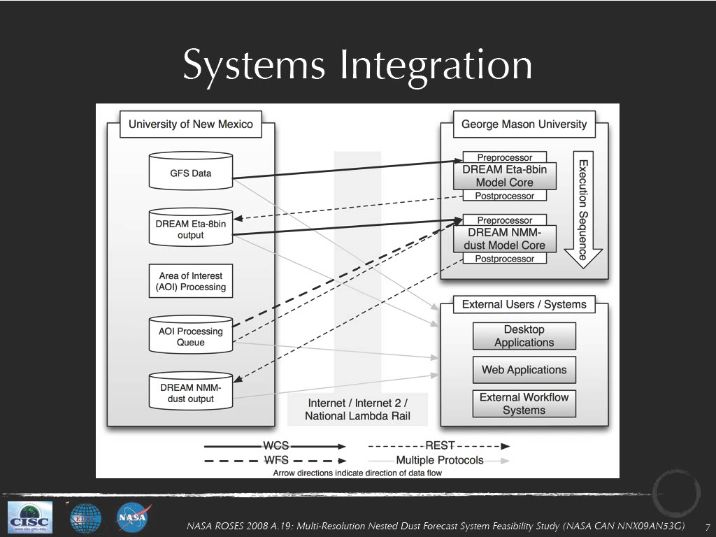
This project builds upon our previous work in the Interoperability Testbed and the PHAiRS projects through two related activities to be undertaken by EDAC and our collaborators at George Mason University (funded by NASA through their 2008 Research Opportunities in Space and Earth Sciences NRA): 1) determining the feasibility of deploying a nested dust forecasting system that consists of initial low spatial resolution (8-bin DREAM ETA) model runs that identify regions for which an HPC-enabled, high-spatial-resolution DREAM NMM model should be run; and 2) developing an interoperable framework that uses OGC and W3C standards to enable model and data interoperability to streamline the execution of the model chain and deliver the products of the model runs into public health decision support systems such as EPHTN and SYRIS.
From 2001 to 2009, EDAC, in conjunction with Natural Heritage New Mexico, mapped the land cover of the 34,000-acre Bandelier National Monument in north-central New Mexico. The monument presented some unique challenges, from an elevation difference of 5,000 feet to a terrain that includes riverine and lacustrine habitats, deep incised canyons, and tall peaks capped by sub-alpine forests. In addition, throughout the project, the region underwent a significant ecological change as the ubiquitous pinyon woodlands suffered a near-total dieback. The mapping process combined multi-temporal, moderate spatial resolution satellite imagery with digital ortho-photos along with the field plot data to detect and classify the different mixes of plant cover types. The resulting map grouped the hundreds of separately identified vegetation communities found at the park into 70 separate land cover types. The resulting map provides the US Park Service with a data source to aid in their management of park resources and a baseline from which to compare future changes.

Beginning in 2005, EDAC in conjunction with Natural Heritage New Mexico mapped the land cover of the 86,000 acre Guadalupe Mountains National Park in western Texas. A diverse range of environments are found in the park from the gypsic dunes and alkali playas on the west side, to the oak scrubland on the east side, to the montane conifer forests in the peaks that rise 4,000 feet above the basin floor. The mapping process combined multi-temporal, moderate spatial resolution satellite imagery with digital ortho-photos along with field plot data to detect and classify the different mixes of plant cover types. The resulting map grouped the hundreds of separately identified vegetation communities found at the park into almost 70 separate land cover types. The resulting map provides the US Park Service with a data source to aid in their management of park resources and a baseline from which to compare future changes.

Almost continuously since 1994, EDAC has provided the Cooperative Monitoring Center (CMC) at Sandia National Laboratories with technical assistance in remote sensing and GIS technology. The mission of the CMC is to demonstrate the various unclassified technologies that can be used in border monitoring, arms control, and international security. EDAC provides expertise in remote sensing and GIS by obtaining satellite imagery and other geospatial data for a variety of CMC international projects. We assist the CMC with border monitoring analyses, modeling, and imagery interpretation. The CMC has a visiting scholars program that hosts a wide range of domestic and international experts, and EDAC assists them with geospatial information and training. We also provide remote sensing presentations and demonstrations at CMC workshops and conferences. Presentations are conducted in Albuquerque, elsewhere domestically, and on occasion, internationally.

 EDAC, in collaboration with UNM’s Bureau of Business and Economic Research (BBER) and under contract to the NM Department of Finance and Administration, addressed the population undercount in the Local Update of Census Addresses (LUCA) Program used to update and improve the U. S. Bureau of Census Master Address File. EDAC used digital aerial imagery for interpreting and counting housing structures within 3,500 Census blocks. These blocks were selected to provide the greatest impact upon areas that are historically the most undercounted due, in large part, to the poor addressing found in these regions. Overall, the program provided an additional 131,283 housing units not previously identified by the Census Bureau enumeration. New Mexico may benefit by as much as $11 million per year in increased federal funding once these additions are accepted by the Census Bureau.
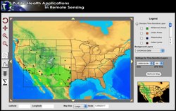 In 2008, the five-year NASA-funded REASoN project known as PHAiRS entered its fifth and final year. This project is unique in that it has successfully modified a dust forecast model for conditions in the southwest United States and improved the model’s performance by using NASA Earth observation data as input parameters. Furthermore, it has engaged the public health communities in Arizona, New Mexico, and Texas in all phases of the project. Significant progress has been made in developing a demonstration web client, the standards-based service-based architecture on which it depends, and the incorporation of EPA in-situ particulate matter concentration data. Most significant is the availability of forecast dust data via Open Geospatial Consortium web services, allowing users to quickly acquire data using time-enabled WMS requests, both through direct requests and through an online KML generation tool for streamlined visualization in desktop virtual globe applications such as Google Earth. In the final months of the project, the PHAiRS capabilities and products will be incorporated into the Syndrome Reporting and Information System (SYRIS) and tested by the City of Lubbock Department of Health and the Texas Department of Health District 1.
Demonstration Movies:

