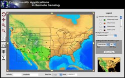
 In 2008, the five-year NASA-funded REASoN project known as PHAiRS entered its fifth and final year. This project is unique in that it has successfully modified a dust forecast model for conditions in the southwest United States and improved the model’s performance by using NASA Earth observation data as input parameters. Furthermore, it has engaged the public health communities in Arizona, New Mexico, and Texas in all phases of the project. Significant progress has been made in developing a demonstration web client, the standards-based service-based architecture on which it depends, and the incorporation of EPA in-situ particulate matter concentration data. Most significant is the availability of forecast dust data via Open Geospatial Consortium web services, allowing users to quickly acquire data using time-enabled WMS requests, both through direct requests and through an online KML generation tool for streamlined visualization in desktop virtual globe applications such as Google Earth. In the final months of the project, the PHAiRS capabilities and products will be incorporated into the Syndrome Reporting and Information System (SYRIS) and tested by the City of Lubbock Department of Health and the Texas Department of Health District 1.
Demonstration Movies:


