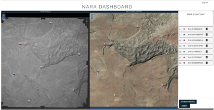
In July 2019, EDAC required a grant through the NARA’s NHPRC (National Archive and Records Administration’s National Historical Publications and Records Commission) to digitize historical aerial photos from 1934-1987. The photos are from New Mexico and nearby regions in neighboring states. Digitizing these photos included a process of scanning, georeferencing, creating metadata, indexing, archiving, and making them web-accessible.
An API was also created by the EDAC IT Team to georeference images and add metadata by users online. The software development is open source and the code is available here.
The project was finished in June 2022, with a grand total of 32,358 images digitized and free to download for the public. These photos can be accessed on historicalaerialphotos.org and RGIS.
As a component of a larger NASA-funded project on the Integration of Airborne Dust Prediction Systems and Vegetation Phenology to Track Pollen for Asthma Alerts in Public Health Decision Support Systems, EDAC is developing a web-based decision support system for forecasting Juniperus ashei, Juniperus monosperma, Juniperus scopulorum, and Juniperus pinchotii pollen concentration data. Designed to meet the requirements of New Mexico’s Environmental Public Health Tracking System (NM EPHTS), the system includes state-of-the-art statistical analysis tools, geospatial visualization tools, data discovery, extraction, and delivery tools, and environmental/public health linkage information. Earth science data obtained from Earth observatories are ingested into the Pollen Regional Atmospheric Model (PREAM) by team members at the University of Arizona. EDAC receives output files from the model which then are run through a post-processing routine to develop products that are made available to NM EPHTS via web mapping and web coverage services.

 EDAC attended the NM Department of Health kick-off for New Mexico’s Environmental Public Health Tracking (EPHT) Program in 2002 and has participated in the NM EPHT Program in the years since. New Mexico is an original Grantee in the Centers for Disease Control and Prevention (CDC) National Environmental Public Health Tracking Program and is currently one of 24 EPHT Grantees. This CDC program provides state health departments with resources to create statewide networks that integrate data sets, tools, and standards, thus allowing the state network to be an interoperable component of the National EPHT Network. New Mexico supports the national EPHT goals to prevent or reduce illnesses, injuries, and deaths related to environmental risk factors and to increase the understanding of the relationships between environmental exposures and health effects.
EDAC develops, implements, and enhances the NM EPHT Network/System (NM Tracking) nmtracking.doh.nm.gov and its relevant data services. NM Tracking consists of a content management system for text- and graphics-based information and an interactive, dynamic data analysis, visualization, and reporting application. The portal provides a secured, publicly accessible, Web-based mechanism to exchange data and information between data stewards, analysts, and New Mexicans and the public; to discover and view data; and to explore relationships between environmental exposures and potential health outcomes. To achieve this, NM Tracking uses an online data registry to make environmental public health information, data, and standardized metadata available for query, visualization, download, and report generation. Data security is ensured through secure Internet transmissions, encrypted messaging, and authenticated and authorized user roles in all communications between NM Tracking and the NMDOH environmental health-data provider NM-IBIS and other distributed data providers.
Exposure to fine particulate dust and adhered endotoxins is an increasing Public Health concern, particularly in the exacerbation of cardiovascular and respiratory diseases. This concern is demonstrated by the deployment (funded by NASA’s REASoN program) of a moderate-resolution dust forecasting system (the DREAM ETA model) into the SYRIS syndromic surveillance system, and through ongoing interest by the NM Department of Health in the deployment of dust, pollen, and other environmental data sets into New Mexico’s Environmental Public Health Tracking Network (EPHTN). In support of these systems, more rapidly available and higher spatial resolution data are needed for more localized assessment of particulate exposure for use in epidemiological studies, and for more timely and targeted notification of dust events to at-risk populations.
Researchers at the University of New Mexico, George Mason University, and the University of Arizona had previously been funded by NASA to conduct an Interoperability Testbed project in 2007 to demonstrate key model and data interoperability capabilities of the Dust Regional Atmospheric Model (DREAM ETA); the higher particle- size resolution, 8-bin DREAM ETA model; and the higher spatial resolution DREAM NMM model.
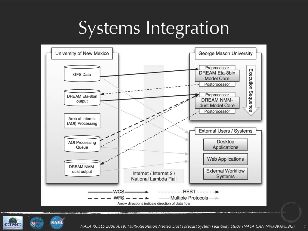
This project builds upon our previous work in the Interoperability Testbed and the PHAiRS projects through two related activities to be undertaken by EDAC and our collaborators at George Mason University (funded by NASA through their 2008 Research Opportunities in Space and Earth Sciences NRA): 1) determining the feasibility of deploying a nested dust forecasting system that consists of initial low spatial resolution (8-bin DREAM ETA) model runs that identify regions for which an HPC-enabled, high-spatial-resolution DREAM NMM model should be run; and 2) developing an interoperable framework that uses OGC and W3C standards to enable model and data interoperability to streamline the execution of the model chain and deliver the products of the model runs into public health decision support systems such as EPHTN and SYRIS.
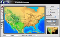 In 2008, the five-year NASA-funded REASoN project known as PHAiRS entered its fifth and final year. This project is unique in that it has successfully modified a dust forecast model for conditions in the southwest United States and improved the model’s performance by using NASA Earth observation data as input parameters. Furthermore, it has engaged the public health communities in Arizona, New Mexico, and Texas in all phases of the project. Significant progress has been made in developing a demonstration web client, the standards-based service-based architecture on which it depends, and the incorporation of EPA in-situ particulate matter concentration data. Most significant is the availability of forecast dust data via Open Geospatial Consortium web services, allowing users to quickly acquire data using time-enabled WMS requests, both through direct requests and through an online KML generation tool for streamlined visualization in desktop virtual globe applications such as Google Earth. In the final months of the project, the PHAiRS capabilities and products will be incorporated into the Syndrome Reporting and Information System (SYRIS) and tested by the City of Lubbock Department of Health and the Texas Department of Health District 1.
Demonstration Movies:
 In conjunction with our application development work, we also provide ongoing hosting of the applications that we develop for particular projects. The specific hosting model will vary from project to project, but the following services are available as part of any hosting package:
Specific hosting solutions are typically customized to meet the requirements of particular applications. The general capabilities that have previously been deployed and hosted on EDAC’s servers include:
While these solutions are just examples of the numerous application development and hosting solutions that EDAC has developed over the past several years, they illustrate the breadth of options available for hosting services provided by EDAC.

