Scroll with your mouse or click pop-out button to read in another window:
 Sep 20,2023
 Comments Off on New Mexico Wildfire Risk Assessment Portal (NMWRAP)
 GIS Projects,All Projects
In collaboration with the Federal Emergency Management Agency (FEMA) under the Cooperating Technical Partners Program (read more…), EDAC created and manages the New Mexico Wildfire Risk Assessment Portal (NMWRAP). In an effort to increase wildfire awareness, NMWRAP is an interactive web map that allows users to view if they are at risk for wildfires in New Mexico. The web map also has tools for users to create maps, and download data and reports.
 Sep 19,2023
Comments Off on National Archive and Records Administration (NARA) Project
All Projects,Image Archive and Data Services,Information Technology Projects
Sep 19,2023
Comments Off on National Archive and Records Administration (NARA) Project
All Projects,Image Archive and Data Services,Information Technology Projects
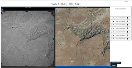
In July 2019, EDAC required a grant through the NARA’s NHPRC (National Archive and Records Administration’s National Historical Publications and Records Commission) to digitize historical aerial photos from 1934-1987. The photos are from New Mexico and nearby regions in neighboring states. Digitizing these photos included a process of scanning, georeferencing, creating metadata, indexing, archiving, and making them web-accessible.
An API was also created by the EDAC IT Team to georeference images and add metadata by users online. The software development is open source and the code is available here.
The project was finished in June 2022, with a grand total of 32,358 images digitized and free to download for the public. These photos can be accessed on historicalaerialphotos.org and RGIS.
Aug 23,2019
Comments Off on New Mexico Office of Secretary of State: Voters & Special Districts Project
GIS Projects,All Projects

The Earth Data Analysis Center provided data collection, data processing, and mapping support to the New Mexico Office of Secretary of State for carrying out work related to the Local Election Act (LEA), which was passed by the New Mexico Legislature in 2018. LEA provides for local elections to be held simultaneously throughout the state of New Mexico. Special voting district boundary data was collected from district contacts and/or their data stewards. The data was processed and made into digital format when necessary, or they can be viewed on the New Mexico Political Subdivisions Map. Voter addresses were standardized and geocoded. Overlay analyses were executed with voter address points, special voting district boundaries, and voting precinct boundaries to determine voter count per area. This work assists in the preparation for future local elections.
The New Mexico 911 (NM911) Program was created by Section 63-9D-1 through 63-9D-20 NMSA 1978 (“Enhanced 911 Act”) to further the public interest and protect the safety, health, and welfare of the people of New Mexico by enabling the development, installation, and operation of enhanced 911 emergency reporting systems to be operated under shared state and local government management and control. The New Mexico Department of Finance and Administration (NM DFA) manages the NM911 Program.
The NM911 Program administers essential emergency reporting and dispatch services accessible by calling nine-one-one through forty-one disparately funded municipal and county-run public safety answering points (PSAPs or 911 centers) located throughout the state.
In January 2019, The NM911 Program contracted with the Earth Data Analysis Center (EDAC) at the University of New Mexico (UNM) and Bohannan Huston, Inc. to securely acquire geospatial data from local government entities, validate and process data into the statewide model; and make such data available for download on the PSAP Map Servers. Earth Data Analysis Center is responsible for securely acquiring GIS data from primary GeoData Providers, verifying and validating data, processing to convert those to the statewide master dataset, generating assessment reports identifying errors or discrepancies per NM911 standards, and providing reports back to the GeoData providers. In addition, these data are updated on PSAP Map servers for emergency response. The road centerlines and address points (statewide) are available on NM RGIS Geospatial Data Clearinghouse as shapefiles for public access.
Feb 18,2014
Comments Off on The Dune Sagebrush Lizard Habitat Map
All Projects,Image Processing Projects
In order to aid in the protection of the dune sagebrush lizard (Sceloporus arenicolus) habitat, Natural Heritage New Mexico (NHNM) is collaborating with EDAC to map its range in detail. The lizard is found only on the shinoak (Quercus havardii) dunelands of southeastern New Mexico, comprising some 1,415,000 acres. As this habitat is a checkerboard of control of federal, state, and private land managers and faces an increasing number of threats from competing land uses, the need to know where important and viable habitat still exists is critical. So beginning in 2011, field crews from NHNM have gone out to the shinoak dunelands and collected and described land cover for a number of ground control plots. These plots have been used by EDAC in turn with multi-temporal Landsat imagery from 2011 as well as the NAIP 2011 digital ortho-photography to create a land cover map at a 1m spatial resolution which is intended to be useful to land managers at a 1:12,000 scale. The area was mapped into 18 different land cover classes, of which the most important is to separate the healthy shinoak dunelands and dune blowouts, which are critical to the survival of the lizard, from areas of disturbance and degraded habitat.

Feb 18,2014
Comments Off on El Malpais National Monument Vegetation Classification and Map
All Projects,Image Processing Projects
As part of an ongoing national program to inventory and map vegetation cover for all of the 280 park units in the United States, EDAC and Natural Heritage New Mexico (NHNM) developed a vegetation map for the 115,000-acre El Malpais National Monument located in western New Mexico. The rugged nature of the topography dominated by lava flows and volcanoes, some only a few thousand years old, made it especially challenging to gather field data and created much more reliance on the imagery to classify the area. Still, NHNM managed to collect some 476 ground plots from 2003 to 2009 which described the vegetation cover for a sample terrain of 400 m2. These ground data sets were then used by EDAC to create a classification from multi-temporal Landsat imagery and natural color digital ortho-photography. The spectral depth and seasonality of the Landsat imagery was used to model differences in surface reflectance and phenology between vegetation types whereas the photography was used to enhance the spatial resolution of the final product. The resulting map classified the park into 12 Map Unit Level 1 classes (equivalent to the NVCS Group level) and 49 Map Unit Level 2 classes (equivalent to the NVCS Alliance level). The completed maps and accompanying reports have been provided to the US National Park Service as digital products to aid in the present and future management of their natural resources.

Feb 17,2014
Comments Off on FEMA RiskMAP and Cooperating Technical Partners Program
GIS Projects,All Projects

FEMA’s Risk Mapping, Assessment, and Planning (RiskMAP) Program’s vision is to provide quality data that increases public awareness and leads to action that reduces risk to life and property. The New Mexico Department of Homeland Security (NMDHSEM) and Earth Data Analysis Center are working with FEMA Region VI as Cooperating Technical Partners through RiskMAP to prioritize flood-related data needs throughout the state. NMDSHEM and EDAC operate the NMFlood website that hosts interactive maps, current flood-related news, and links to online flooding tools and are active in the New Mexico Floodplain Managers Association and New Mexico Silver Jackets.
Feb 17,2014
Comments Off on Developing a Web-Based Decision Support System for Forecasting Pollen Bursts
All Projects,Image Processing Projects,Information Technology Projects
As a component of a larger NASA-funded project on the Integration of Airborne Dust Prediction Systems and Vegetation Phenology to Track Pollen for Asthma Alerts in Public Health Decision Support Systems, EDAC is developing a web-based decision support system for forecasting Juniperus ashei, Juniperus monosperma, Juniperus scopulorum, and Juniperus pinchotii pollen concentration data. Designed to meet the requirements of New Mexico’s Environmental Public Health Tracking System (NM EPHTS), the system includes state-of-the-art statistical analysis tools, geospatial visualization tools, data discovery, extraction, and delivery tools, and environmental/public health linkage information. Earth science data obtained from Earth observatories are ingested into the Pollen Regional Atmospheric Model (PREAM) by team members at the University of Arizona. EDAC receives output files from the model which then are run through a post-processing routine to develop products that are made available to NM EPHTS via web mapping and web coverage services.

Feb 6,2014
Comments Off on Earth Science Day 2014 @ NM State Roundhouse – Poster 3
Sample Products,RGIS Data Clearinghouse Projects

Feb 6,2014
Comments Off on Earth Science Day 2014 @ NM State Roundhouse – Poster 2
Sample Products,RGIS Data Clearinghouse Projects

Feb 6,2014
Comments Off on Earth Science Day 2014 @ NM State Roundhouse – Poster 1
Sample Products,RGIS Data Clearinghouse Projects

Feb 6,2014
Comments Off on New Mexico’s Ghost Towns Landscape
Sample Products,RGIS Data Clearinghouse Projects
New Mexico’s history of mining and exploration makes it home to hundreds of abandoned settlements. Intrepid research into the history of these settlements yielded a compilation of our state’s documented ghost towns. Here is a link to the interactive map.
The data used to create this map, which includes names, locations, and the condition of the ghost town, are available for download from RGIS.

The New Mexico Broadband Program (NMBB) began in 2010 as part of the National Telecommunications and Information Administration (NTIA) State Broadband Initiative (SBI), which implemented the joint purposes of the American Recovery and Reinvestment Act of 2009 and the Broadband Data Improvement Act. The SBI program facilitated the integration of broadband and information technology into state and local economies.
After that initiative was completed, EDAC continued working with the New Mexico Department of Information Technology (DoIT) on several other broadband projects, such as the Governor’s Broadband for Education Initiative, PSFA Broadband Deficiencies Correction Program (BDCP), and the NM Rural Broadband Project (RBBP). In 2022 the Office of Broadband Access and Expansion (OBAE) and the Connect New Mexico Fund (CNMF) were created. This later gave way to the Connect New Mexico Pilot Program (CNMPP), a grant program that allows awarded Internet Service Providers (ISPs) to bring broadband to unserved and underserved communities.
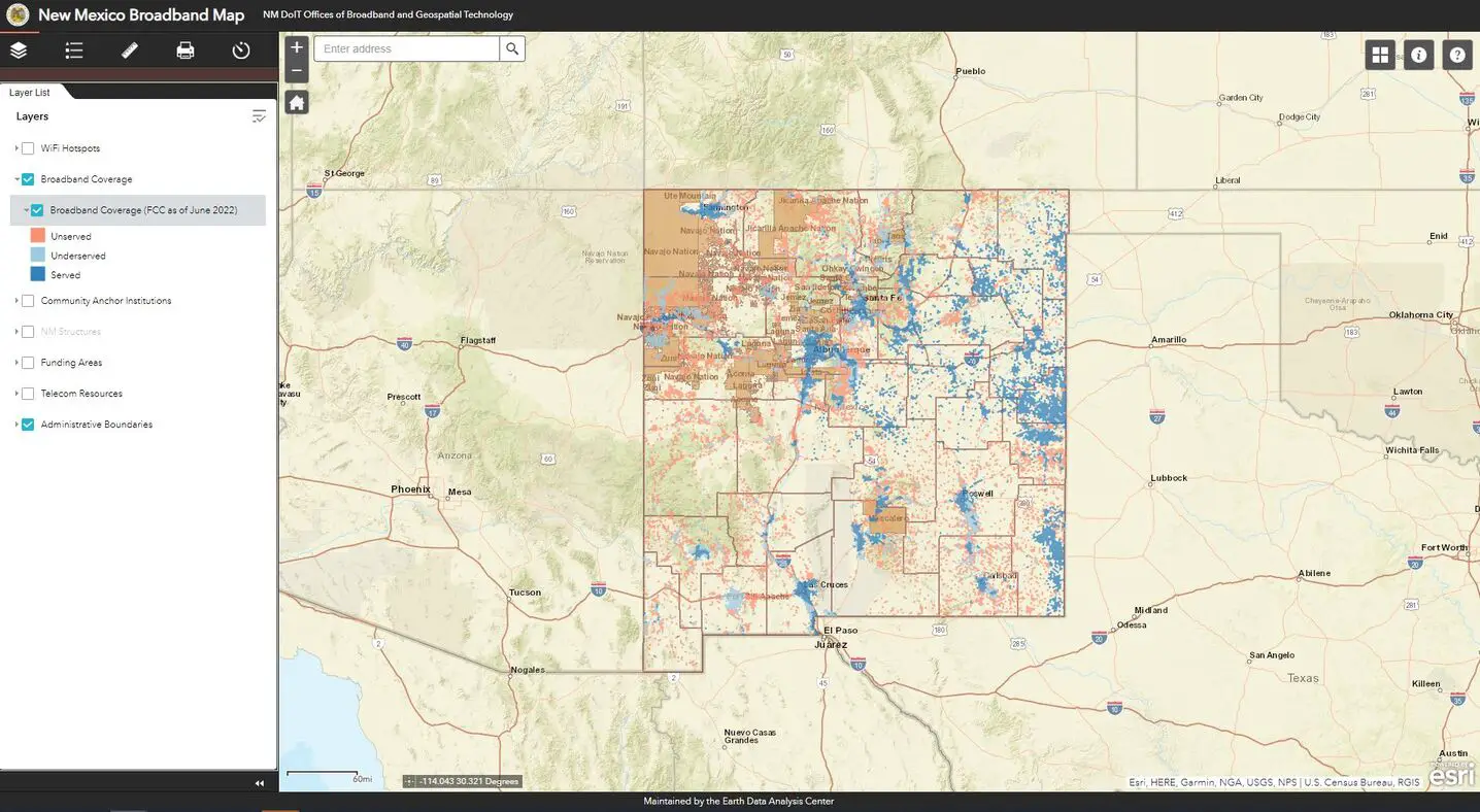
EDAC continues to maintain the New Mexico Broadband Map (NMBB Map), which had originally been created in partnership with DoIT for the NTIA SBI project. The NMBB Map, http://nmbbmapping.org/mapping/, is an interactive web map that displays broadband availability based on download/upload speeds: Served (100/20 Mbps or more), Underserved (from 25/3 Mbps to just under 100/20 Mbps), and Unserved (less than 25/3 Mbps). This data is derived from the Federal Communications Commission (FCC)’s Broadband Serviceable Locations (BSL) data. The NMBB Map also includes other relevant data: Community Anchor Institutions (CASA database), NM structures, funding areas, telecom resources, WiFi hotspots, and administrative boundaries for reference.
The map allows consumers to see broadband availability and policymakers to address the barriers for broadband expansion and to improve broadband adoption in underserved and unserved communities. The adoption of high-speed Internet services and information technology enhances economic development, public safety, health care, educational opportunities, and the quality of life for New Mexicans.
 EDAC attended the NM Department of Health kick-off for New Mexico’s Environmental Public Health Tracking (EPHT) Program in 2002 and has participated in the NM EPHT Program in the years since. New Mexico is an original Grantee in the Centers for Disease Control and Prevention (CDC) National Environmental Public Health Tracking Program and is currently one of 24 EPHT Grantees. This CDC program provides state health departments with resources to create statewide networks that integrate data sets, tools, and standards, thus allowing the state network to be an interoperable component of the National EPHT Network. New Mexico supports the national EPHT goals to prevent or reduce illnesses, injuries, and deaths related to environmental risk factors and to increase the understanding of the relationships between environmental exposures and health effects.
EDAC develops, implements, and enhances the NM EPHT Network/System (NM Tracking) nmtracking.doh.nm.gov and its relevant data services. NM Tracking consists of a content management system for text- and graphics-based information and an interactive, dynamic data analysis, visualization, and reporting application. The portal provides a secured, publicly accessible, Web-based mechanism to exchange data and information between data stewards, analysts, and New Mexicans and the public; to discover and view data; and to explore relationships between environmental exposures and potential health outcomes. To achieve this, NM Tracking uses an online data registry to make environmental public health information, data, and standardized metadata available for query, visualization, download, and report generation. Data security is ensured through secure Internet transmissions, encrypted messaging, and authenticated and authorized user roles in all communications between NM Tracking and the NMDOH environmental health-data provider NM-IBIS and other distributed data providers.
Director & Geospatial Program Manager

![]() sbaros@edac.unm.edu
sbaros@edac.unm.edu![]() (505) 277-3624
(505) 277-3624
Shirley V. Baros, GISP is the EDAC Director and has served as the Geospatial Program Manager for the Earth Data Analysis Center since 1990. She is responsible for project implementation, management and development. During Ms Baros’ twenty-five year tenure with the EDAC GIS Program she has been involved in collaborative projects with a wide-variety of clients ranging from local to international programs. Recent projects include geospatial analysis mapping for the New Mexico Department of Information Technology, the Department of Health, New Mexico Minerals and Natural Resources Forestry Division, US Bureau of Census, Federal Emergency Management Agency (FEMA), Center for Disease Control and Prevention (CDC) Native Diabetes Wellness Program, National Science Foundation (EPSCoR) and multiple NASA funded projects.
Ms. Baros’ research interests include relational database development, data mining and integration of spatial and non-spatial data, the application of computer-intensive methods to large geospatial data analysis problems, and web-based mapping and data delivery systems.
Associate Director

![]() szhang@edac.unm.edu
szhang@edac.unm.edu
![]() (505) 277-3035
(505) 277-3035
Dr. Su Zhang is the Associate Director of the Earth Data Analysis Center (EDAC) at the University of New Mexico (UNM). Dr. Zhang is also an Assistant Professor in the Department of Geography and Environmental Studies and the Department of Civil, Construction, and Environmental Engineering at UNM. Dr. Zhang obtained his Ph.D. in Civil Engineering from UNM in 2017. He also received Master’s Degrees in GIScience and Construction Management from UNM in 2016 and 2010, respectively. Dr. Zhang defines his professional identity as a geospatial engineer and data scientist, with a specific focus on leveraging geospatial and information technologies to address real-world challenges in the domains of infrastructure and environment. His current research endeavors revolve around the application of remote sensing, Geographic Information Systems (GIS), web mapping, and uninhabited aircraft systems (UAS) technologies for infrastructure and environmental management. Dr. Zhang has been at the forefront of both methodological and applied research within the geospatial engineering field for over a decade. Dr. Zhang has been engaged by many federal and state agencies, as well as private firms, to take on the role of Principal Investigator (PI) in the design and evaluation of GIS-based spatial decision support systems.
Research & Information Manager
![]() sandeep@edac.unm.edu
sandeep@edac.unm.edu![]() (505) 277-3622
(505) 277-3622
Sandeep Talasila is the Research & Information Manager at the Earth Data Analysis Center. He is a certified GIS Professional (GISP). He completed his Masters in Engineering Science from Louisiana State University. At EDAC he oversees the Image Archive Program and works on a wide variety of GIS projects including the development of web-mapping applications. Mr. Talasila is the current President of New Mexico Geographic Information Council (NMGIC).
Programmer Analyst 3

![]() hbarrett@edac.unm.edu
hbarrett@edac.unm.edu![]() (505) 2773040
(505) 2773040
Mr. Barrett has experience in a range of technical areas, spanning from client-side to server-side applications and databases. He is familiar with several programming languages such as Python, GoLang, PHP, and Javascript. His interest in GIS has led him to explore both commercial and open-source technologies. With a background in systems administration, he has a practical understanding of networking concepts, including the OSI model and the TCP/IP stack.
Educationally, Mr. Barrett earned a BA in Management Information Systems and has held certifications such as Security+, Network+, and A+. His experience extends to collaborating on projects supported by various government entities and private organizations.
GIS Analyst/Programmer

![]() lsinclair@edac.unm.edu
lsinclair@edac.unm.edu![]() (505) 277-3023
(505) 277-3023
Lisa Sinclair received her Master of Science in Geography from the University of New Mexico in 2009 and came to EDAC as a student in 2008. Following that, she worked with Natural Heritage New Mexico at UNM, and was an instructor for the UNM Department of Geography. She returned to EDAC as staff in 2021. Ms. Sinclair completed graduate research on the positional accuracy of GPS and is interested in a wide range of GIS and remote sensing applications including biogeography, earth sciences, modeling, machine learning, and deep learning. Ms. Sinclair is a doctoral student at The Pennsylvania State University where she is completing a Doctor of Engineering degree with a research focus in remote sensing and earth observation. Ms. Sinclair is a past board member and President of the New Mexico Geographic Information Council (NMGIC).
GIS Specialist/Programmer

![]() (505) 277-3622
(505) 277-3622
Paul Neville received a Bachelors of Science in Geology from the University of Texas and a Masters of Arts in Geography from the University of New Mexico. He came to EDAC as a student in 1990 where he worked in the Image Processing Services. He became a part of the EDAC staff in February 1993. Paul has worked with data from a number of satellite and aerial platforms. He has worked on a variety of remote sensing studies including those involving general geologic mapping, mineral exploration, structural interpretation, vegetation surveys and land use analysis. A key interest of his is the integration of Geographic Information Systems (GIS) and Global Positioning Systems technology into the applications. He is familiar with a number of different image processing packages, but he works with ERDAS regularly as well as the ESRI® ArcGIS Desktop and Server software.
Accountant
![]() smentz@edac.unm.edu
smentz@edac.unm.edu![]() (505) 277-3622
(505) 277-3622
Sandra Mentz has more than 19 years accounting experience. She has been an accountant at the Earth Data Analysis Center for the past thirteen years. Previously she worked at the First National Bank in the Trust Operations Department. Sandra is responsible for reimbursements and assists EDAC in development and management of budgets.
GIS Specialist/Programmer

![]() spenman@edac.unm.edu
spenman@edac.unm.edu![]() (505) 277-4000
(505) 277-4000
Dr. Shawn Penman is a GIS Specialist/Programmer at the Earth Data Analysis Center at the University of New Mexico. She came to EDAC as a student and became a part of the EDAC Staff in 2002. Dr. Penman has 20 years of GIS experience and is a certified GIS Professional (GISP) and a Flood Plain Manager (CFM). Dr. Penman received her PhD in Anthropology from University of New Mexico in 2002. Her project experience includes GIS applications for Emergency Management, Wildland fire mapping, and interactive web mapping. She has worked with different software technologies such as ESRI® ArcGIS Desktop and Server, ArcGIS Web APIs – Flex, Silverlight, FEMA Hazus, and ERDAS Imagine. Recently, Dr. Penman has taught GIS in the UNM Geography department as well as for the NMSU NM EDGE Program. She is a member of New Mexico Geographic Information Council (NMGIC). And currently serves as Secretary for the New Mexico Floodplain Managers Association.
Programmer Analyst 2

![]() teshelman@edac.unm.edu
teshelman@edac.unm.edu![]() (505) 277-3040
(505) 277-3040
Tyler Eshelman joined EDAC as a student programmer in 2019, and became a full staff member in February 2021 after receiving a Bachelor of Science Degree in Geography with a minor in Computer Science from The University of New Mexico. Tyler is a Full Stack Developer and Graphic Designer with a strong background in programming and a focus on Geographic Information Systems (GIS). Tyler specializes in interdisciplinary programming, combining his expertise in GIS with various programming languages and techniques. His experience includes programming and script development for GIS applications, developing Application Programming Interfaces (APIs), database design and management, and the development of Graphic User Interfaces (GUI) for web application development and web mapping. He is proficient with many programming languages, including, but not limited to, Python, C++, JavaScript, and PHP. Combining his expertise in GIS with his programming skills. Tyler has been leading the development on a variety of ongoing projects at EDAC funded by various federal, state, and local government agencies as well as private firms.
Programmer Analyst I

![]() (505) 277-3010
(505) 277-3010
Eric Crozier joined EDAC in 2022 as the system administrator. He received a bachelor’s degree in computer science, and a minor in mathematics earlier that year from UNM. In 2024 he was promoted to Programmer Analyst I. He has other achievements, but they’re currently commented out.
GIS Analyst/Programmer

![]() (505) 277-3574
(505) 277-3574
Arlin Arpero received her Bachelor of Science in Geography from the University of New Mexico in 2022. She joined EDAC as a Student Technician in the Image Archive department in 2021. She is now a full-time GIS Programmer Analyst at EDAC.
GIS Analyst/Programmer
![]() aschondel@edac.unm.edu
aschondel@edac.unm.edu![]() (505) 277-3009
(505) 277-3009
Abby Schondel received her Bachelor of Arts in Anthropology in 2017, and went on to graduate with a Master of Applied Geography in 2020 from NMSU. Her graduate research focused on how public geohumanities projects shape perceptions of local landscapes and their human and non-human inhabitants. Before joining EDAC as a Programmer Analyst in 2026, Abby served in local government and interned with Conservation Corps New Mexico (CCNM) as a Rangeland GIS Technician.
System Administrator

![]() (505) 277-4658
(505) 277-4658
Chris Girlamo graduated from UNM in 2020 with a Bachelors of Science in Geography and a Bachelors of Business Administration in Management Information Systems. He went on to get his Masters of Science in Geography from UNM in 2023, focusing on quantifying the risk local Navajo Nation communities faced from radioactive waste generated by abandoned uranium mine sites. After graduating he worked as a consultant at various inactive uranium mine sites throughout the Southwest United States, specializing in data management and spatial modeling of radioactive waste. Chris joined EDAC in 2025 as a system administrator.
GIS Manager

![]() (505) 277-3623
(505) 277-3623
Dr. Theodros Woldeyohannes is the GIS Manager of the Earth Data Analysis Center (EDAC) at the University of New Mexico (UNM). Dr. Woldeyohannes completed his PhD in geography at the Department of Geography and Environmental studies, and has affiliations with the UNM METALS Superfund Research Program, New Mexico INSPIRES Center, and the UNM Center for Native Environmental Health Equity Research. He also received a Master’s Degree in Environmental Science from the Rochester Institute of Technology (RIT) in 2020. Dr. Woldeyohannes considers himself a GIScientist and geospatial data scientist, with an interest in applying geospatial technologies for addressing environmental health issues and understanding the spatial patterns behind exposure and human-environment interactions. He also has expertise in environmental sampling and exposure modeling, such as assessing exposure to particulate air pollution from forest fires, mining operations, and other sources in at-risk communities. Some of Dr. Woldeyohannes’s recent work includes assessment of fires in the American waste management stream using remote sensing and Internet of Things (IoT) ground sensors, use of IoT ground sensors for community air quality monitoring, and understanding individual-scale exposure through mixed-methodologies.
Programmer Analyst I

![]() (505) 277-3010
(505) 277-3010
Jack Taylor joined EDAC as a Programmer Analyst in 2025. He received a Bachelors of Arts in Geography from Virginia Tech in 2020 and a Masters of Science in GIS from the University of Maryland in 2022. Jack has previously worked for the US Forest Service and US Geological Survey as a Geographer and GIS Specialist. His project experience includes spatial analyses for predicting burn severity, forest degradation monitoring, and surface water detection. Jack has also worked as a wildland firefighter and bird bander. He specializes in python programming, remote sensing, and ecology.

