 Sep 20,2023
 Comments Off on New Mexico Wildfire Risk Assessment Portal (NMWRAP)
 GIS Projects|All Projects
In collaboration with the Federal Emergency Management Agency (FEMA) under the Cooperating Technical Partners Program (read more…), EDAC created and manages the New Mexico Wildfire Risk Assessment Portal (NMWRAP). In an effort to increase wildfire awareness, NMWRAP is an interactive web map that allows users to view if they are at risk for wildfires in New Mexico. The web map also has tools for users to create maps, and download data and reports.
 Sep 19,2023
Comments Off on National Archive and Records Administration (NARA) Project
All Projects|Image Archive and Data Services|Information Technology Projects
Sep 19,2023
Comments Off on National Archive and Records Administration (NARA) Project
All Projects|Image Archive and Data Services|Information Technology Projects
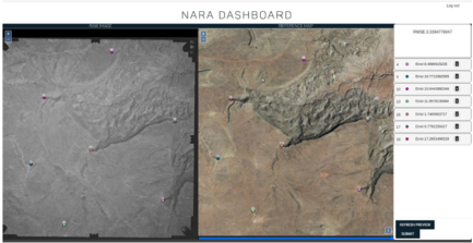
In July 2019, EDAC required a grant through the NARA’s NHPRC (National Archive and Records Administration’s National Historical Publications and Records Commission) to digitize historical aerial photos from 1934-1987. The photos are from New Mexico and nearby regions in neighboring states. Digitizing these photos included a process of scanning, georeferencing, creating metadata, indexing, archiving, and making them web-accessible.
An API was also created by the EDAC IT Team to georeference images and add metadata by users online. The software development is open source and the code is available here.
The project was finished in June 2022, with a grand total of 32,358 images digitized and free to download for the public. These photos can be accessed on historicalaerialphotos.org and RGIS.
Aug 23,2019
Comments Off on New Mexico Office of Secretary of State: Voters & Special Districts Project
GIS Projects|All Projects

The Earth Data Analysis Center provided data collection, data processing, and mapping support to the New Mexico Office of Secretary of State for carrying out work related to the Local Election Act (LEA), which was passed by the New Mexico Legislature in 2018. LEA provides for local elections to be held simultaneously throughout the state of New Mexico. Special voting district boundary data was collected from district contacts and/or their data stewards. The data was processed and made into digital format when necessary, or they can be viewed on the New Mexico Political Subdivisions Map. Voter addresses were standardized and geocoded. Overlay analyses were executed with voter address points, special voting district boundaries, and voting precinct boundaries to determine voter count per area. This work assists in the preparation for future local elections.
GIS Analyst/Programmer

![]() (505) 277-3622 x242
(505) 277-3622 x242
Arlin Arpero received her Bachelor of Science in Geography from the University of New Mexico in 2022. She joined EDAC as a Student Technician in the Image Archive department in 2021. She is now a full-time GIS Programmer Analyst at EDAC.

